Posts mit dem Label Urs Steiner werden angezeigt. Alle Posts anzeigen

Sonntag, 6. Oktober 2013

Mappers Blog: Field notes of Urs Steiner


fig.1. La Givrine 2011. Base Map (1m contours, index contours, vegetation and some details from the aerial image (wall, track)). Field note (naturalistic but blue for 406 and green for 408, no eraser but pencil for the "final line", cross for stones,..). Steiner mapped this map for the WOC 2012 Middle Distance Final. Before the WOC the map was revisioned (fig.2.).
fig.2. Differences between the maps Givrine 2011 and WOC 2012.
The last revision had three main issues: the threshold for undergrowth (407/409) was raised. Some clearances where added or altered (near control points). Top and bottom-features (112 small knoll, 115 small depression) where replaced by equivalent contour-line features.

Mittwoch, 3. April 2013

Mappers Blog: Base for mapping Uaul Grond

I am leaving for Switzerland for some weeks. The Hemfosa project will rest until the snow has melted away. Instead I will be mapping a part of the Uaul Grond, by the way my favorite part of my favorite forest (Uaul la Teua and Uaul la Crusch). Here I share  a sample of my base map with you.
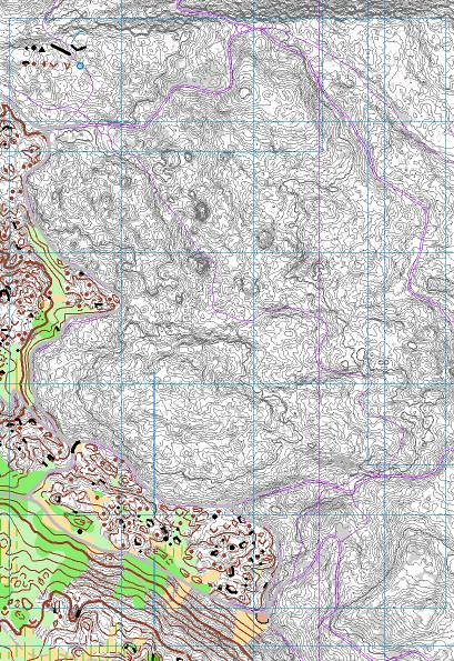
fig.1. Basemap for mapping Uaul la Teua

Some details:
  • The base map itself bases on Laserdata, offical measurement data (violet), older maps and actual maps alongside.
  • As the terrain is very detailed  I am mapping 1:3500 for a 1:10K map to get some space for clean drawing. The less detailed part I map in 1:5K as usual. I try to keep the base map as decent as possible, so I print it out in grey-scale.
  • As the terrain is complex the contourlines are provided with slopelines. Equidistance is 1m.
  • The vegetation information (available from OCAD11, alt. Karttapullautin) I reduced to this grey surfaces in the background (grey means: No high or intermediate trees).
  • Some size-reference objects in the upper left corner
  • the blue mesh for referencing the field notes
  • the other blue lines to organize the overlap of the different sheets
  • violet: data from official measurents, but the laser data is expected to be more precise
  • the bordering track of the existing map in the lower left corner is set to grey in case it has to be adapted
  • Additionally I will carry with me a print of the  map from 2000 mapped by Gian-Reto Schaad, Urs Steiner and Beat Imhof. I guess I can always learn from them.


Donnerstag, 2. September 2010

OL-Kartenaufnahme mit Laserscanning-Daten [von Urs Steiner]

Urs Steiner hat mir die Unterlagen seines Vortrages zur Kartenaufnahme mit Laserscanning anlässlich des Kartenaufnehmerkurses vom 1.Mai 2010 zur Verfügung gestellt. Zur weiteren Verbreitung seiner Erfahrungen werde ich diese hier wiedergeben.


[autorisiert US 21.7.2010]

o-zeugs over and out (late wc china finding)

Yes. Let the o-zeugs blog rest in peace. I´ll take it down eventually. And yes, I stumbled over the decisions of the Ethics Panel regarding ...