Freitag, 29. August 2014

A summary from the centrum ok traininglab.

I here resume my time as a member in the training committee of centrum ok, this absolutely outstanding club in many concerns. One of these is that the club consist mainly of people in the middle age, mainly beginners or coming back after longer absences and pretty few holding on since youth. As the club was only founded eight years ago it has a nice lack of tradition which gave me the opportunity to test some orienteering trainings I was theorizing about earlier or to which I was inspired by others.

Generalisation / contour lines

r.du..d m.p

Concept: The map is reduced on the leg (only contours and some important symbols) but complete inside the circle.
Conclusion: Pretty demanding.

Routechoices

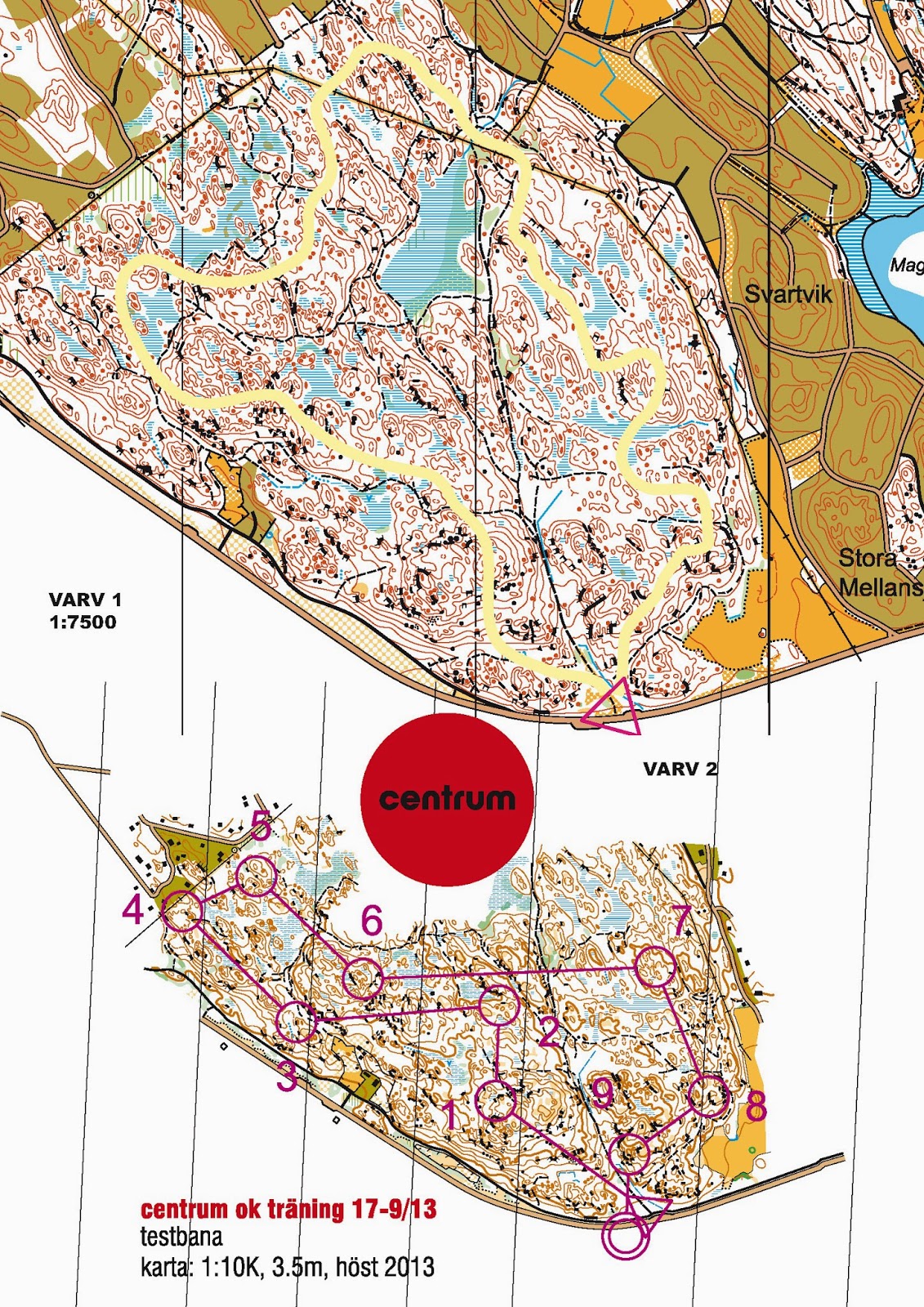
The route test (I against I against I)

Concept: The participant runs the same loop three times on different routes to really evaluate his/her route choices.
Conclusion: Interesting

Just a looong leg 

Concept: What the name says: Just a looong leg.
Conclusion: Fun I GPS and 2DRerun are involved.

Being Jerk R. m.m.

Concept: A night-training for beginners. A veteran leads a group of beginners through the course  and loudly shares his concepts and reflections.
Conclusion:  Pretty effective and good for the integration of the new ones into the club.

Compass

 The tree moves (compass-training)

Concept: Here we trained  proper compass handling by focusing on the bodies moves. (1. To hold a direction turn your body until compass, map and the bodies vector get in accordance.  2. While the bodies temporary leaves the accordance, keep map and compass in it by outbalancing with your arm 3. If you change direction you are aiming to, turn your map and then bring everything into accordance)
Conclusion: Positive response

Compass Maze

Concept: This is supposed to be a compass training in three parts: A long leg, a maze and a series of short, turning controls. Especially the maze is demanding as it forces the participant to work with most objects only on-sight.
Conclusion: Very demanding.

 Stay on the line

Concept: Another night compass training. This time the task is to stay on the use the compass to stay on the purple line wherever it is applied.
Conclusion: Demanding and useful.

Pac Man Maze

 Concept: Another maze with the special feature, that "monsters"  may not be are moving inside the maze which may not be intersect.
Conclusion: Demanding fun!

The straight corridor

Concept: Straight corridors to train a combination of compass and detailed navigation
Conclusion:  Useful, especially in terrain which otherwise is known or as dominant track network.

 Broad view

Anti-corridor

Concept: Participants try to stay on the line, masking the map. That way they are forced to navigate the map aside the line to succeed.
Conclusion: Tough and useful.

On sight orienteering

Concept: A control is punched as soon as it is spotted (I got this from okansas). Most of the controls are marked with a colored ribbon. Some have actually flag. There the team switches role from  spotter to controller and vice versa.
Conclusion: Demanding for the participants and the organizer

The  eagle eye

 Concept: Training in pairs (spotter & controller). On the way to the control the pair must mandatory spot the objects marked by green circles. Pointing out shall happen as early as the object gets in sight. To put the pressure on the spotter, the controller will point out that s/he saw the object about ten seconds after it happened. Change of the rolls as soon the spotter spotted the regular control or the respective object. Discussion after the training on the different usability of objects as beacon.
Conclusion: maybe a bit too much? Nice layout by Daniel though.

The Sailor

Concept: Another anti-corridor combined with the some "missing control objects". Both aim to train a broad view.
Conclusion: Demanding and useful (plus nice layout by Daniel)

Mapreading

Golf orienteering

 Concept: Train longer map contacts by trying to minimize them.
Conclusion: Fine and Fun.

Relay

Malus-Massstart

Concept:  the performance in our club is spread. So you need to think of training setting fun for everybody. In this case me and Daniel tried to keep the group together by letting the pack leaders run some extra controls. We therefore grouped the controls. At every control we fixed pile with a elaborated number of post-its (the earlier in a "group" the more). Participants punched by picking one sheet (as long as there where sheets left). As long as one managed to get a sheet s/he was allowed to continue. Instead as soon as all sheets were picked one should proceed directly to the beginning of the next group of controls.
Conclusion: Fun!

Jukola-training (in pairs)

Concept: On our level   independent route choice at big relays is almost ever the wrong choice. It is more often faster to stay in the pack and to control what the pack actually is doing. In this exercise we build teams of two runners equipped with to different maps (see above). The first leads on the long leg towards his/her control, being there, the second takes over the lead to his/her own forking and than on the following longer leg, while the other, following keeps track on where the pair is actually running to. etc.
Conclusion: Useful.

Jukolatraining with focus on start

Concept: One particular thing with the big relays is, that you never know exactly when to start until 45 seconds before you will have to. In this exercise we combined a pretty common midsummer night-training  with the element of the big relay (not mass-) start element.  We let them start hasty, we let them start late, we let them start alone, in groups and in a chasing position. All directed by a prepared timed script which is read at the start. Another element I used here where unanounced forkings.
Conclusion: Fun and useful to simulate.

Tactics and fun

Team Orienteering

Concept: A team has to complete a course (punch the controls in the right order) but must not stay together all the way.  This is a common competitive discipline in Switzerland. The course should open the many possibilities to short-cut opening up for the tactial and coordinative game.
Conclusion: Fun!

Dart-orienteering

Concept: A one hour score orienteering with the specialty, that the participants are only allowed to pick a certain number of controls before returning to the starting point. The number for each turn is defined by how good they perform with darts. Thus something like biathlon.
Conclusion: Fun.

Dienstag, 26. August 2014

Mappers blog: Gemsfairen - 31 years of orienteering mapping

Last weekend the Swiss Long Champs were held on the balcony of Gemsfairen. The terrain is alpine and pretty remote and therefore seldom used. The last orienteering map over the terrain was produced in 1983 as it was planed to hold the Swiss Champs 1984 on it, but the latter had to be cancelled because of snow. The year after a national competition was held in compensation (no snow then, but ice cold rain :-P). I put on the corresponding excerpts of the 1983 (src: OL KTV Altdorf) and the 2014 (src:Daniel Hubmann) map of the location Tüfels fridhof (Devils cemetery).
There are many interesting points to see in this comparison both in regard to the production of the map (Laser, professional mappers, OCAD) as to the maps content (new mapping norm, lowered level of generalization and legibility, surge of form lines) maybe even in regard of course setting?

Donnerstag, 21. August 2014

Couch-Mapper: From .las to map without one lung full of fresh air

I here describe the way of the couch-mapper or with other words how far you can get with a swedish .las file (and karttapullautin, OL Laser, Open Street Map, Open Orienteering Mapper and OCAD).

This is a beta version to be enhanced by your feedback.

Preparation

  • If the map you want stretches over more than one  tile, use lasmerge to put them all together.Too big files should be avoided though.
  • Use las2las or OL-Laser to clip the laser data to the maps perimeter
  • Additionally create some suitable smaller clips you can use for the optimization of
    • vegetation mapping
    • cliff generation
    • marsh generation 
  • Create an OCAD file 1:10000 with the according symbol set. Set the reference system to SWEREF 99 TM.

Vegetation mapping

Contours

Small knolls

  • Small knolls you also get from karttapullautin
  • Use the dotknolls.dxf
  • Import into OCAD11 applying a CRT-file or use the function OCAD11>Map>Convert imported layers to symbols after the import.
  • Readability: Look over the knolls in regard of the minimal gap to the contours. Move apart if necessary.

Cliffs

  • Cliffs you get from OL Laser by creating two sets cliffs, 203 passable rock face (angle 50, height 1.5m, minimal length 5m, snap distance 1m) and 201 impassable cliff (angle 55, height 2.5m, minimal length 8m, snap distance 5m)
    • Open the exported .ocd file in OCAD
    • Set the reference system to the SWEREF 99TM; save
  • Import the .ocd files (do not add colors or symbols thereby)
  • Readability: Look over the passable rock faces
    • Select all the cliffs shorter than 0.6mm; manually replace them with the point symbol for minimal cliff (0.6mm)
    • Draw the longer cliffs with an elegant bezier-curve
    • Delete the auto generated cliffs
  • Readability: Look over the impassable cliffs
    • There should be no cliff shorter than the minimal length of 0.6mm (ISOM 2000)
    • Replace the auto generated cliffs with the ones you draw.

Water bodies

  • Water bodies digitize yourself based on the a point classification (Laserpunktklass>>Default) image created with OL-Laser.

Marshes / flat terrain

  • In this area the marshes mostly are flat. Therefore you can use a base map from OL-Laser to digitize potential marshy areas.
  • Basemap: Terrain grid 3x3m; Lutning , 1px; y=-50x2+0x+255;
  • 311 is thereby more a symbol for flat terrain. Here you got some freedom to interpret. Develop experience. Double check with aerial photos from eniro.
  • The national terrain map 1:50000 can be used as extra information. The approximate position of the bigger marshes can be found there.

Tracks

  •  Some tracks can be identified with a slope-image (Grid 1x1m; Lutning>Default) or by the intensity image (Grid 1x1m; Intensitet>Default) generated with OL-Laser 
  • Digitize yourself
  • Alternatively the tracks can be imported from Open Street Map alike the buildings; see below
  • Readability: Apply dash vertices

Buildings

  • If you are lucky, someone already digitized the buildings for Open Street Map and you can just download them.
    • Choose the part you want to download from Open Street Map. Save as .osm file.
    • Open a new map 1:10000 in Open Orienteering Mapper
    • Import the .osm-file
    • Georeference the map, by adding the SWEREF 99 TM proj4 - key
      +proj=utm +zone=33 +ellps=GRS80 +towgs84=0,0,0,0,0,0,0 +units=m +no_defs
    • Choose "lutning" so that the "grivation" is 0. (Swedish maps are orientated after the reference system)
    • Symbolize the content you want, remove the rest, save as .ocd
    • Import into OCAD, seems that the georeference gets lost thereby and you have to position the imported "layer" manually. Good if you could identify the position of one of the buildings before importing.
  • If you are less lucky, no one digitized the buildings you needed for Open Street Map. As you regularly benefit of Open Street Map the time has come now to contribute. Digitize the buildings on Open Street Map based on aerial images and than proceed as described under the point above.
  • Readability: Replace to small buildings with the symbol for the minimal building according to 526 building.
  • Other vector data can be integrated from Open Street Map the same way.

Magnetic north lines

The final result


Open questions

  • How to import a geo-referenced file from OOM to OCAD without loosing the geo reference
  • An easier way to get to the buildings (the buildings are automatically removed from the .las , maybe one could work with the thereby made holes).
  • More information to take from the karttapullautin-dxf-files  / a workflow to integrate cliffs from karttapullautin
  • How to distinguish open rock from open grassland and maybe a smart setting to define the area 402 half open land with scattered trees in karttapullautin

Dienstag, 19. August 2014

That is what we all prefer

Meiner Meinung nach reduziert das Anschauen einer neuen Karte den Reiz, beim Startsignal in ein unbekanntes Abenteuer zu starten.
Daniel Hubmann in Swiss Orienteering Forum

Montag, 11. August 2014

For the records: WOC Sprint 2014

Tue (Lassen) har lagt tre månader på att rita en karta över Venedig. Och den är mer detaljerad än den karta som vi sprang VM på. Vi har lagt väldigt många timmar i googlestreetview på att gå igenom varenda passage. På kartan som Tue har ritad har vi lagt många banor, och så har vi suttit hemma och testat för att veta vilket vägval som man ska ta. När vi kom till andra kontrollen och läste in långsträckan till trean märkte jag att den här sträckan har jag sett många gånger tidigare. Jag visste att jag skulle titta på det högra vägvalet. På kontrollen efter kartbytet visste jag att jag skulle vänster. Det ger väldigt mycket självförtroende inför starten att jag vet hur det skulle komma se ut, och snabbt ta de bästa vägvalen.
Sören Bobach, skogsport 6/2014

Till sprinten in Venedig valde arrangörerna stt ställa till det en aning för löparna genom att  lägga  en kontroll utanför det avlysta området, och detta lurade flera av löparana.
Måten Lång, skogsport 6/2014

Actually I would have liked more fences in Venice, because a lot of legs were quite boring, and I already knew the best routechoices.
Tue Lassen

The KanPas Focus 200

So here is the KanPas Focus 200. Actually the compass making orienteering easy. Maybe even too easy? - Sorry for that. fig.1. What a beauty ...