
Sonntag, 23. November 2014
Overprepared Competitions: Ski-O EM 2015
The organizers of the 2015 European Champs in Ski Orienteering decided to publish an auto-generated map over the competition area to ensure same conditions for all competitors.
The area had not been mapped before, but the data used for the maps generation is freely available. Additional data as the set-up of the public ski track network from here and here can easily be added. Maybe even direct from your own GPS-device?
Samstag, 22. November 2014
Swiss Team Preparations for WCup Final Switzerland
Taken from the Swiss Orienteering Magazine 11-2014:
Julia Gross nimm zur mentalen Vorbereitung des Wiss Teams Stellung und erzählt: "Wir haben auf der alten Galms-Karte Bahnen gelegt. Ich glaube, es waren zum Schluss acht verschiedene Vorschläge." Die Bahnkonzepte haben die Läuferinnen auf "Dropbox" gestellt, um sie allen Teammitgliedern zugänglich zu machen. Dieses Angebot haben selbstverständlich nicht alle im gleichen Ausmass benutzt. Für dieses vorgängige Kartenstudium hat Judith Wyder nicht viel Zeit aufgewendet, doch sie präzisiert: "Für mich war es wichtig, zu wissen, welche Forststrassen Steigungen aufweisen, denn dies könnte im Wettkampf unbesonnen übersehen werden."Text by Thomas Hodel.
Das tolle Teamresultat verdeutlicht, dass die Schweizerinnen mental gut vorbereitet waren. Auch einige Stimmen dazu bestätigen dies, so Elena Roos: "Ich habe es genauso erwartet. Wenn sich die Möglichkeit bietet (sic), so habe ich wie im Vorraus vorgenommen, die Wegroute gewählt." Und Julia Gross ergänzt: "Im Team haben wir das Bahnkonzept vom siebten Posten bis ins Ziel genau richtig erraten." Es zeigt sich zudem, dass sich die Schweizerinnen auf der langen Teilstrecke richtig entschieden haben. Einzig eine schlechte Ausführung der Route führte zu einem Zeitverlust.
Donnerstag, 30. Oktober 2014
Swiss Selections 2015
Here you find an update of my chart visualizing the careers of the members of the Swiss National Team since 1999.
Freitag, 29. August 2014
A summary from the centrum ok traininglab.
I here resume my time as a member in the training committee of centrum ok, this absolutely outstanding club in many concerns. One of these is that the club consist mainly of people in the middle age, mainly beginners or coming back after longer absences and pretty few holding on since youth. As the club was only founded eight years ago it has a nice lack of tradition which gave me the opportunity to test some orienteering trainings I was theorizing about earlier or to which I was inspired by others.
 Concept: The map is reduced on the leg (only contours and some important symbols) but complete inside the circle.
Conclusion: Pretty demanding.
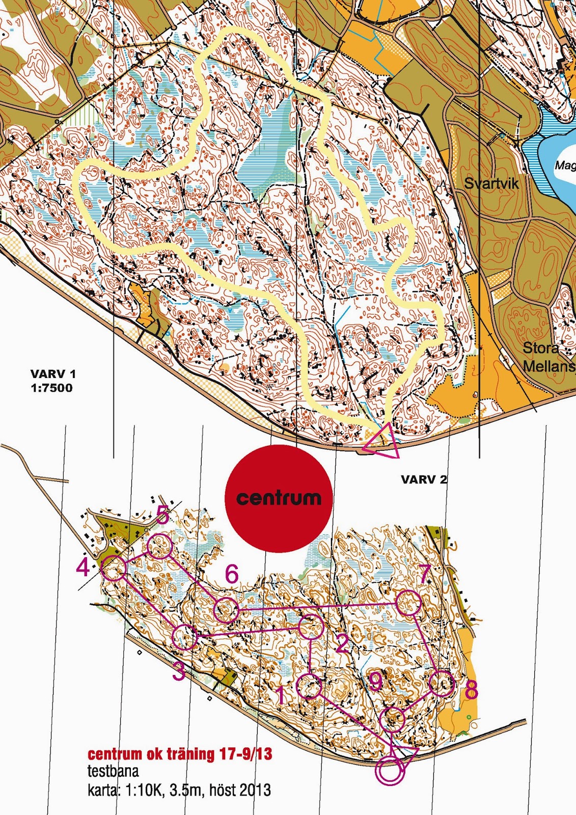
 Concept: The participant runs the same loop three times on different routes to really evaluate his/her route choices.
Conclusion: Interesting
 Concept: What the name says: Just a looong leg.
Conclusion: Fun I GPS and 2DRerun are involved.
 Concept: A
night-training for beginners. A veteran leads a group of beginners
through the course and loudly shares his concepts and reflections.
Concept: A
night-training for beginners. A veteran leads a group of beginners
through the course and loudly shares his concepts and reflections.
Conclusion: Pretty effective and good for the integration of the new ones into the club.
 Concept: Here we trained proper compass handling by focusing on the bodies moves. (1. To hold a direction turn your body until compass, map and the bodies vector get in accordance. 2. While the bodies temporary leaves the accordance, keep map and compass in it by outbalancing with your arm 3. If you change direction you are aiming to, turn your map and then bring everything into accordance)
Conclusion: Positive response
 Concept: This
is supposed to be a compass training in three parts: A long leg, a maze
and a series of short, turning controls. Especially the maze is
demanding as it forces the participant to work with most objects only
on-sight.
Concept: This
is supposed to be a compass training in three parts: A long leg, a maze
and a series of short, turning controls. Especially the maze is
demanding as it forces the participant to work with most objects only
on-sight.
Conclusion: Very demanding.
Stay on the line
Concept: Another
night compass training. This time the task is to stay on the use the
compass to stay on the purple line wherever it is applied.
Conclusion: Demanding and useful.
 Concept: Another maze with the special feature, that "monsters" may not be are moving inside the maze which may not be intersect.
Conclusion: Demanding fun!
 Concept: Straight corridors to train a combination of compass and detailed navigation
Conclusion: Useful, especially in terrain which otherwise is known or as dominant track network.
 Concept: Participants try to stay on the line, masking the map. That way they are forced to navigate the map aside the line to succeed.
Conclusion: Tough and useful.
 Concept: A control is punched as soon as it is spotted (I got this from okansas). Most of the controls are marked with a colored ribbon. Some have actually flag. There the team switches role from spotter to controller and vice versa.
Conclusion: Demanding for the participants and the organizer
 Concept: Training in pairs (spotter & controller). On the way to the control the pair must mandatory spot the objects marked by green circles. Pointing out shall happen as early as the object gets in sight. To put the pressure on the spotter, the controller will point out that s/he saw the object about ten seconds after it happened. Change of the rolls as soon the spotter spotted the regular control or the respective object. Discussion after the training on the different usability of objects as beacon.
Conclusion: maybe a bit too much? Nice layout by Daniel though.
 Concept: Another anti-corridor combined with the some "missing control objects". Both aim to train a broad view.
Conclusion: Demanding and useful (plus nice layout by Daniel)
 Concept: Train longer map contacts by trying to minimize them.
Conclusion: Fine and Fun.
 Concept:
the performance in our club is spread. So you need to think of training
setting fun for everybody. In this case me and Daniel tried to keep the
group together by letting the pack leaders run some extra controls. We
therefore grouped the controls. At every control we fixed pile with a
elaborated number of post-its (the earlier in a "group" the more).
Participants punched by picking one sheet (as long as there where sheets
left). As long as one managed to get a sheet s/he was allowed to
continue. Instead as soon as all sheets were picked one should proceed
directly to the beginning of the next group of controls.
Concept:
the performance in our club is spread. So you need to think of training
setting fun for everybody. In this case me and Daniel tried to keep the
group together by letting the pack leaders run some extra controls. We
therefore grouped the controls. At every control we fixed pile with a
elaborated number of post-its (the earlier in a "group" the more).
Participants punched by picking one sheet (as long as there where sheets
left). As long as one managed to get a sheet s/he was allowed to
continue. Instead as soon as all sheets were picked one should proceed
directly to the beginning of the next group of controls.
Conclusion: Fun!

 Concept: On our level independent route choice at big relays is almost ever the wrong choice. It is more often faster to stay in the pack and to control what the pack actually is doing. In this exercise we build teams of two runners equipped with to different maps (see above). The first leads on the long leg towards his/her control, being there, the second takes over the lead to his/her own forking and than on the following longer leg, while the other, following keeps track on where the pair is actually running to. etc.
Conclusion: Useful.
.jpg) Concept: One particular thing with the big relays is, that you never know exactly when to start until 45 seconds before you will have to. In this exercise we combined a pretty common midsummer night-training with the element of the big relay (not mass-) start element. We let them start hasty, we let them start late, we let them start alone, in groups and in a chasing position. All directed by a prepared timed script which is read at the start. Another element I used here where unanounced forkings.
Concept: One particular thing with the big relays is, that you never know exactly when to start until 45 seconds before you will have to. In this exercise we combined a pretty common midsummer night-training with the element of the big relay (not mass-) start element. We let them start hasty, we let them start late, we let them start alone, in groups and in a chasing position. All directed by a prepared timed script which is read at the start. Another element I used here where unanounced forkings.
Conclusion: Fun and useful to simulate.
 Concept:
A team has to complete a course (punch the controls in the right order)
but must not stay together all the way. This is a common competitive
discipline in Switzerland. The course should open the many possibilities
to short-cut opening up for the tactial and coordinative game.
Concept:
A team has to complete a course (punch the controls in the right order)
but must not stay together all the way. This is a common competitive
discipline in Switzerland. The course should open the many possibilities
to short-cut opening up for the tactial and coordinative game.
Conclusion: Fun!
 Concept: A one hour score orienteering with the specialty, that the participants are only allowed to pick a certain number of controls before returning to the starting point. The number for each turn is defined by how good they perform with darts. Thus something like biathlon.
Conclusion: Fun.
Generalisation / contour lines
r.du..d m.p
Conclusion: Pretty demanding.
Routechoices
The route test (I against I against I)
Conclusion: Interesting
Just a looong leg
Conclusion: Fun I GPS and 2DRerun are involved.
Being Jerk R. m.m.
Conclusion: Pretty effective and good for the integration of the new ones into the club.
Compass
The tree moves (compass-training)
Conclusion: Positive response
Compass Maze
Conclusion: Very demanding.
Stay on the line

Concept: Another
night compass training. This time the task is to stay on the use the
compass to stay on the purple line wherever it is applied.Conclusion: Demanding and useful.
Pac Man Maze
Conclusion: Demanding fun!
The straight corridor
Conclusion: Useful, especially in terrain which otherwise is known or as dominant track network.
Broad view
Anti-corridor
Conclusion: Tough and useful.
On sight orienteering
Conclusion: Demanding for the participants and the organizer
The eagle eye
Conclusion: maybe a bit too much? Nice layout by Daniel though.
The Sailor
Conclusion: Demanding and useful (plus nice layout by Daniel)
Mapreading
Golf orienteering
Conclusion: Fine and Fun.
Relay
Malus-Massstart
Conclusion: Fun!
Jukola-training (in pairs)
Conclusion: Useful.
Jukolatraining with focus on start
Conclusion: Fun and useful to simulate.
Tactics and fun
Team Orienteering
Conclusion: Fun!
Dart-orienteering
Conclusion: Fun.
Dienstag, 26. August 2014
Mappers blog: Gemsfairen - 31 years of orienteering mapping
Last weekend the Swiss Long Champs were held on the balcony of Gemsfairen. The terrain is alpine and pretty remote and therefore seldom used. The last orienteering map over the terrain was produced in 1983 as it was planed to hold the Swiss Champs 1984 on it, but the latter had to be cancelled because of snow. The year after a national competition was held in compensation (no snow then, but ice cold rain :-P). I put on the corresponding excerpts of the 1983 (src: OL KTV Altdorf) and the 2014 (src:Daniel Hubmann) map of the location Tüfels fridhof (Devils cemetery).

 There are many interesting points to see in this comparison both in regard to the production of the map (Laser, professional mappers, OCAD) as to the maps content (new mapping norm, lowered level of generalization and legibility, surge of form lines) maybe even in regard of course setting?
Donnerstag, 21. August 2014
Couch-Mapper: From .las to map without one lung full of fresh air
I here describe the way of the couch-mapper or with other words how far you can get with a swedish .las file (and karttapullautin, OL Laser, Open Street Map, Open Orienteering Mapper and OCAD).
This is a beta version to be enhanced by your feedback.


This is a beta version to be enhanced by your feedback.
Preparation
- If the map you want stretches over more than one tile, use lasmerge to put them all together.Too big files should be avoided though.
- Use las2las or OL-Laser to clip the laser data to the maps perimeter
- Additionally create some suitable smaller clips you can use for the optimization of
- vegetation mapping
- cliff generation
- marsh generation
- Create an OCAD file 1:10000 with the according symbol set. Set the reference system to SWEREF 99 TM.
Vegetation mapping
- Use karttapullautin to generate a vegetation layer. This will build the background of your map. See also karttapullautins vegetation mapping guide
Contours
- Contours you calculate with karttapullautin. Choose the appropriate equidistance.
- Use the out2.dxf from the generated temp-folder.
- Import it into OCAD11 applying a CRT-file. Give contours representing depressions their own symbols.
- Readability: Look over the depressions and manually add 102 slope lines to clarify where necessary.
- Readability: Look over knolls and hilltops. Replace those being to small depending to the situation by 112 small knoll, 113 elongated knoll or 111 minimal knoll according to 112&113 (contour 6x12m).
- Readability: Look over the form lines drawing adding a dash vertex at the right place.
Small knolls
- Small knolls you also get from karttapullautin.
- Use the dotknolls.dxf
- Import into OCAD11 applying a CRT-file or use the function OCAD11>Map>Convert imported layers to symbols after the import.
- Readability: Look over the knolls in regard of the minimal gap to the contours. Move apart if necessary.
Cliffs
- Cliffs you get from OL Laser by creating two sets cliffs, 203 passable rock face (angle 50, height 1.5m, minimal length 5m, snap distance 1m) and 201 impassable cliff (angle 55, height 2.5m, minimal length 8m, snap distance 5m)
- Open the exported .ocd file in OCAD
- Set the reference system to the SWEREF 99TM; save
- Import the .ocd files (do not add colors or symbols thereby)
- Readability: Look over the passable rock faces
- Select all the cliffs shorter than 0.6mm; manually replace them with the point symbol for minimal cliff (0.6mm)
- Draw the longer cliffs with an elegant bezier-curve
- Delete the auto generated cliffs
- Readability: Look over the impassable cliffs
- There should be no cliff shorter than the minimal length of 0.6mm (ISOM 2000)
- Replace the auto generated cliffs with the ones you draw.
Water bodies
- Water bodies digitize yourself based on the a point classification (Laserpunktklass>>Default) image created with OL-Laser.
Marshes / flat terrain
- In this area the marshes mostly are flat. Therefore you can use a base map from OL-Laser to digitize potential marshy areas.
- Basemap: Terrain grid 3x3m; Lutning , 1px; y=-50x2+0x+255;
- 311 is thereby more a symbol for flat terrain. Here you got some freedom to interpret. Develop experience. Double check with aerial photos from eniro.
- The national terrain map 1:50000 can be used as extra information. The approximate position of the bigger marshes can be found there.
Tracks
- Some tracks can be identified with a slope-image (Grid 1x1m; Lutning>Default) or by the intensity image (Grid 1x1m; Intensitet>Default) generated with OL-Laser
- Digitize yourself
- Alternatively the tracks can be imported from Open Street Map alike the buildings; see below
- Readability: Apply dash vertices
Buildings
- If you are lucky, someone already digitized the buildings for Open Street Map and you can just download them.
- Choose the part you want to download from Open Street Map. Save as .osm file.
- Open a new map 1:10000 in Open Orienteering Mapper.
- Import the .osm-file
- Georeference the map, by adding the SWEREF 99 TM proj4 - key
+proj=utm +zone=33 +ellps=GRS80 +towgs84=0,0,0,0,0,0,0 +units=m +no_defs
- Choose "lutning" so that the "grivation" is 0. (Swedish maps are orientated after the reference system)
- Symbolize the content you want, remove the rest, save as .ocd
- Import into OCAD, seems that the georeference gets lost thereby and you have to position the imported "layer" manually. Good if you could identify the position of one of the buildings before importing.
- If you are less lucky, no one digitized the buildings you needed for Open Street Map. As you regularly benefit of Open Street Map the time has come now to contribute. Digitize the buildings on Open Street Map based on aerial images and than proceed as described under the point above.
- Readability: Replace to small buildings with the symbol for the minimal building according to 526 building.
- Other vector data can be integrated from Open Street Map the same way.
Magnetic north lines
- Are to be added in OCAD. OCAD11>Map>create map grid ...
- The calculation of the angle of the north lines = meridian-convergence - magnetic declination
- Readability: clip parts of the north lines affecting the readability of the map
The final result
Open questions
- How to import a geo-referenced file from OOM to OCAD without loosing the geo reference
- An easier way to get to the buildings (the buildings are automatically removed from the .las , maybe one could work with the thereby made holes).
- More information to take from the karttapullautin-dxf-files / a workflow to integrate cliffs from karttapullautin
- How to distinguish open rock from open grassland and maybe a smart setting to define the area 402 half open land with scattered trees in karttapullautin
Dienstag, 19. August 2014
That is what we all prefer
Meiner Meinung nach reduziert das Anschauen einer neuen Karte den Reiz, beim Startsignal in ein unbekanntes Abenteuer zu starten.Daniel Hubmann in Swiss Orienteering Forum
Montag, 11. August 2014
For the records: WOC Sprint 2014
Tue (Lassen) har lagt tre månader på att rita en karta över Venedig. Och den är mer detaljerad än den karta som vi sprang VM på. Vi har lagt väldigt många timmar i googlestreetview på att gå igenom varenda passage. På kartan som Tue har ritad har vi lagt många banor, och så har vi suttit hemma och testat för att veta vilket vägval som man ska ta. När vi kom till andra kontrollen och läste in långsträckan till trean märkte jag att den här sträckan har jag sett många gånger tidigare. Jag visste att jag skulle titta på det högra vägvalet. På kontrollen efter kartbytet visste jag att jag skulle vänster. Det ger väldigt mycket självförtroende inför starten att jag vet hur det skulle komma se ut, och snabbt ta de bästa vägvalen.Sören Bobach, skogsport 6/2014
Till sprinten in Venedig valde arrangörerna stt ställa till det en aning för löparna genom att lägga en kontroll utanför det avlysta området, och detta lurade flera av löparana.Måten Lång, skogsport 6/2014
Actually I would have liked more fences in Venice, because a lot of legs were quite boring, and I already knew the best routechoices.Tue Lassen
Freitag, 25. Juli 2014
WOC 1981 klassische Distanz - Erinnerungen des Bahnlegers
Preface: This text is written by Dieter Hulliger and published in the latest newsletter of the classic o challenge . The second day of this years competition will be held in the terrain Les Alpettes used for the WOC 1981 and never since (??). The arranging committee accepts late entries. Contact info@classic-o-challenge.ch
The map of the WOC 81 classic distance you get in this article
The map of the WOC 81 classic distance you get in this article
Seit der WM 81 sind 33 Jahre verstrichen, ein Drittel Jahrhundert, und seither war ich nie mehr in diesem Waldteil! Natürlich war ich gespannt, wie es dort heute aussieht. Umso überraschter war ich, dass der Wald im Teil, wo wir damals gestartet waren, noch fast gleich aussieht: offener, hochstämmiger Mischwald, der auch heute noch gut belaufbar ist. Auch scheinen die Wald- und Gemeindearbeiter hier die Wälder nicht rigoros mit Fahrstrassen zu erschliessen. Nur sehr wenige Wege wurden seither gebaut, und die meist an der Stelle der bestehenden.Dieter Hulliger
Wenn ich an Les Alpettes denke, so taucht in mir immer wieder das Bild der schindelgedeckten Häuser mit den aus dem Dach auslaufenden Kaminen auf. Diese Häuser, stehen immer noch am Weg zum damaligen und auch heutigen Startort. Ebenfalls prägend war der berauschende Ausblick auf den Genfersee vom höchsten Punkt der WM-Bahn. Diesen Blick konnten die WM-Läufer aber leider nicht geniessen: dichter Nebel lag damals dort oben! Das musste auch derjenige Helfer erleben, der sich hinsichtlich dieser Aussicht freiwillig für die Bewachung der eigens für die WM eingerichteten Funk-Relaisstation zuoberst auf Les Alpettes gemeldet hat. Er hat den ganzen Tag weder den Genfersee noch einen Läufer gesehen…
Zusammen mit Roland Hirter habe ich also damals die Bahnen gelegt. Und wie es früher an Weltmeisterschaften üblich war, versuchten auch wir unsere Bahnen ziemlich gestreckt und in einem eleganten Bogen vom Start zum Ziel zu führen. Schlaufen, Achter und Aneinanderreihen von kurzen Teilstrecken lag damals absolut nicht drin! Das Grundprinzip war Routenwahl auf möglichst allen Teilstrecken, höchstens ein paar Verschiebestrecken wurden toleriert. Eigentlich beabsichtigten wir, den Start etwas weiter oben zu machen um den ganzen nordseitigen Abhang von Les Alpettes zu nutzen. Da man aber die ursprünglich vorgesehene Wiese fürs Ziel nicht benutzen konnte, musste der Start nach unten verlegt werden. Die Bahnen wären sonst viel zu lang geworden. Besonders bei der Damenbahn hatten wir Probleme mit der vorgegebenen Laufzeit. Trotz meinen damaligen Laufvermögen konnte ich damals die gewünschte Siegerzeit im Test nur knapp erreichen. Da meinte Roland Hirter trocken: Annichen Kringstad läuft das dann schon – und so war es auch! Als Bemerkung zu meinem Laufvermögen sei erwähnt; dass ich mich damals problemlos für die WM qualifiziert hätte, bei der Selektion aber erklären musste, dass ich leider nicht teilnehmen könne; ich sei nämlich Bahnleger für die WM.
Zentralort der WM war Thun. Der Einzellauf wurde in Les Alpettes ausgetragen, die Staffel in Le Cernets bei Les Verrières. Das ergab ziemliche weite Fahrten. Diejenige nach Les Alpettes geschah per Bus. In den Jura fuhr man mit Zug und Bus. Damals war üblich, dass OL am Morgen stattfanden und nicht wie heute am Nachmittag-Abend, denn Direktübertragungen im Fernsehen gab es noch nicht, die Aufnahmen wurden meistens im Studio noch aufgearbeitet. Bei diesem Anfahrtsweg mussten die Läufer ziemlich früh aus den Federn, fast so früh wie die Postenmannschaften. Und für eine von diesen wurde der Tag dann besonders lang: man hat sie schlicht und einfach im Wald vergessen! Wie sie zurückkam, weiss ich auch nicht mehr. Und wenn
wir schon beim Vergessen sind: Ein weiteres Missgeschick passierte beim Verpflegungsposten. Hier bemerkte man das Fehlen der Trinkbecher erst kurz vor dem Eintreffen der ersten Läufern! Ein in der Nähe des Postens Campierender konnte dann mit seinen Bechern aushelfen…
Geheimhaltung des WM-Geländes war damals ein Muss. So wurde der Austragungsort erst am Abend vorher bekannt gegeben. Es wussten nur sehr wenige Eingeweihte im Voraus, wo die Läufe stattfanden. Die Geheimhaltung hat man so weit getrieben, dass nicht einmal die Holzfäller im Wald informiert wurden, und prompt krachte während des Wettkampfes ein Baum in der Nähe einer erschreckten Läuferin zu Boden. Am
Tag nach dem Einzellauf fand ein Nationaler OL im selben Wald statt. Wir mussten auch diese Bahnen legen. Da gab’s im Vorfeld schon etliche Posten anzuschauen und zu markieren. Ein Glück, dass damals noch nicht so viele Bahnen gelegt werden mussten wie das heute an Nationalen OL der Fall ist.
An ein Erlebnis, das ich beim Markieren der Posten hatte, erinnere ich mich noch besonders: Unterwegs traf ich einen Bauern an, der natürlich fragte, was ich denn da mache. Ich erklärte ihm, was OL ist. Er wollte die Karte sehen und zeigte mir darauf ohne zu zögern, wo wir uns befanden, wo er wohnte und andere Details – sicher hatte er noch nie eine OL-Karte in den Fingern gehabt!
Und wie habe ich den WM-Tag damals erlebt? Ich weiss noch, dass wir am Abend vorher in Gruyères ein (oder mehrere) Raclette gegessen hatten. Am andern Morgen mussten wir, wie die Wettkämpfer auch, natürlich früh aus den Federn und die Posten setzen oder die Postenmannschaften hinführen. Ich liess es mir nicht nehmen,
einen Testlauf der Herrenbahn zu machen. An jedem Posten habe ich noch die Postenmannschaft instruiert oder nötigenfalls umplatziert, wenn sie trotz Armeeblachen von weitem sichtbar waren oder eine der roten Mützen trugen, die unsere OL-Frauen gestrickt hatten und vor und an der WM verkauften! Jedenfalls lief ich die Strecke in einer nicht allzu schlechten Zeit, aber zum Trost der damals wegen meinem Verzicht enttäuschten Trainer, Weltmeister wäre ich damit nicht geworden. Gewonnen hat der über Jahre dominierende Norweger Oyvin Thon in einer fantastischen Zeit. Ich sehe ihn noch heute, wie er nach dem Start locker und elegant den Hang hinunter kurvte, als hätte er Ski an den Füssen.
Die Siegerzeiten in Les Alpettes entsprachen ziemlich genau den Vorgaben. Dies gelang uns dann beim Staffellauf nicht. Offensichtlich waren die Bahnen in Les Verrières zu lang und schwierig, oder die Norweger hatten, einmal mehr, am Vorabend ihren WM-Sieg zu sehr gefeiert….
Dienstag, 20. Mai 2014

Mittwoch, 5. März 2014
DV Entscheid aufgehoben
Wie an der DV auf gerichtliche Vorgabe hin bekannt gemacht wurde, konnten zwei hängige Verfahren vor dem Amtsgericht Olten-Gösgen letztlich mit einer Kompromisslösung und einem Rückzug der beiden Klagen beendet werden. Dabei geht es um den Beschluss der DV vom 6. März 2010, mit dem der Zentralvorstand beauftragt wurde, Massnahmen zur Einschränkung der Handlungen von Thomas Scholl im OL zu ergreifen. Die Delegierten nahmen ohne Wortbegehren zur Kenntnis, dass der DV-Entscheid von 2010 damit aufgehoben ist.source: Swiss Orienteering
Abonnieren
Posts (Atom)
o-zeugs over and out (late wc china finding)
Yes. Let the o-zeugs blog rest in peace. I´ll take it down eventually. And yes, I stumbled over the decisions of the Ethics Panel regarding ...

-
 Die Karte in besserer Auflösung gibt es in meiner Dropbox (5 MB) Die Rubrik ol früher bezieht sich auf die Zeit vor der Omnipräsenz des I...
 -
 Yes. Let the o-zeugs blog rest in peace. I´ll take it down eventually. And yes, I stumbled over the decisions of the Ethics Panel regarding ...