Here is a glympse on the locator-and basemaps I composed for the coming project, a revision of Zürichberg (fig.1.). As the relief is generally unspectacular, I will not be able to use the micro-contour relief (fig.2-3) as an location-tool. So I hope vegetation height (fig.4) and conifers (fig.5) will do the trick.
fig.1 The old map from 2008.
fig.2. ... a relief ...
fig.3. ... the contours 1.25m ...
fig.4. ... the clearings ...
fig.5. ... and finally the conifers.
Figures 3-5 are pngs with transparencies, thus can be used combined.
Posts mit dem Label Open Orienteering Mapper werden angezeigt. Alle Posts anzeigen
Posts mit dem Label Open Orienteering Mapper werden angezeigt. Alle Posts anzeigen
Mittwoch, 18. Mai 2016
Freitag, 5. Februar 2016
Mappers Blog: Use an external GPS to work with Mapper on Android
As my colleagues at Orienteering Mappers Int. reported some difficulties to get their external GPS linked to OCAD on a Windows OS, I thought I would just test how well this went with Mapper on Android...
fig.1. Heading for a happy end: Mapper on Android and SXBlue II GPS.
To get to use an external GPS on Mapper there are two basic steps to do:
1) Pair the GPS with your phone via Bluetooth.
fig.1. Heading for a happy end: Mapper on Android and SXBlue II GPS.
To get to use an external GPS on Mapper there are two basic steps to do:
1) Pair the GPS with your phone via Bluetooth.
- Put the GPS on
- Enable the phones Bluetooth
- Scan for new devices
- Pair phone and GPS by entering the PIN.
- Install the app Bluetooth GPS on your phone
- Get developper status on your phone
- Change the setting "Allow Mock Locations" to yes
- Open Bluetooth GPS; connect; enable Mock GPS provider.
Mittwoch, 28. Oktober 2015
Mappers Blog: Bannwald Setup/ Symbolization, localization and cartography
fig.1. Map from 1984
Assessment
I had to figure out, how to tackle the task and there where basically two questions to answer.1) How to get there? - The slope is situated from 700 to 1000 a.s.l. and starts about 250m above the closest transport stop in Küssnacht a.R. (about 50km from where I live). There is a cable car running up to Seebodenalp but with a restricted time table and a restricted connection to the public transport. No cheap accomodation in the area. I can not loose to much time getting there and away.
2) How to localize? The regional council provides us with a laser-DEM and -DSM but it was produced in back in 2002. This means it has a relatively poor point density, is rastered, filtered (extracted leaf-trees), smoothed (extracted boulders) and in regard of the vegetation partly outdated. Thus a pretty oldtimer compared with a nowadays point cloud. In a relatively uniform slope with lots of stones and cliffs and rocks but also green features to be localized, such a base is not sufficient. As the slope is facing north-east GPS is no big help (actually when ever was GPS a help :-P).
New tools
Thus I was forced to update my setup and did this by:1) Buying a scooter
fig 2. A scooter is the mappers best friend...
2) Borrowing a Range Finder
fig.3. No! The Range Finder is the mappers best friend.
It is a TruPulse Range Finder able to measure horizontal and vertical distances, something especially handy in steep terrain.
Usual Hardware/Software-Setup
Otherwise I the setup has not changed essentially since my last documentation. I am still very happy with the combination of OOMapper on a waterproofed Samsung Galaxy Note 2 (inductive pen technology).fig.4. The Bannwald Setup (note the waterproofed pen)
Hybridal Mapping with OOMapper
One of the advantages of OOMapper compared with OCAD is the possibility to map hybridal: While you can digitize smaller features right away, you just can sketch features "under construction" f.ex. contours and larger areas with undergrowth.fig.5. Screenshot Hybridal Mapping with OOMapper.
Symbolization, localization and cartography
For me nowadays, mapping is a three step procedure, symbolization, localization and cartography (generalization & legibility) or with other words: What (aka ISOM)? Where on the map? and Does the map work (aka cartography)?Localization
While it was a big part of the job to localize map features correctly in the older days, I aspire to have this problem solved beforehand. Localization should generally be no big question. In the case of Bannwald I could base localization on these three base maps I could switch between.fig.6. As done before I work with the 1.25m contours which also work as bands for contour and evtl. form-lines. Basemap calculated with OL Laser.
fig.7. The contours I combine with the vegetation height (the contour layer is semi-transparent). Basemap calculated with OCAD.
fig.8. Rarely I also used the steepness perspective. Basemap calculated with OL Laser.
Finally the mentioned range finder was the crucial tool in regard of localization. The model I borrowed would be able to directly communicate with OCAD by bluetooth. Although myself working with OOMapper I had to manually draw the measured distances on the map. For this purpose I used a helper symbol consisting in a 20m long scale.
fig.9. Helper symbol 20m scale
fig.10. Map draft with included range finder measurements.
Life cartography
Besides the possibility to switch between base maps as it suits you best, digital mapping has an other big advantage in contrast to the good old analog one: Now cartography can be considered on-site. I do this by using a set special set of symbols, I developed for the purpose of field work. This leads to that all cartographic conflicts can be solved right away.fig.11. Some symbols of the field set.
Hence
So this was probably the hardest job I ever made spending 18 days to map 1.3 sqkm. If I would not have adapted my setup, it would have taken much longer. The map will be published next spring to be used for the 39.Innerschwyzer OL. Come and try!Dienstag, 5. Mai 2015
Mappers Blog: Fürstenwald setup
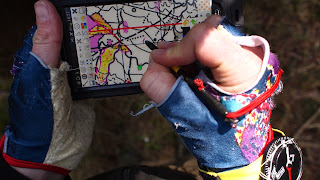 |
| fig.1. Fürstenwald setup. |
The point with digital mapping is, that you can choose your base map according to the actual task.
Hardware
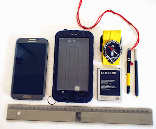 |
| fig.2. The overview |
- Samsung Galaxy Note 2, 5.5 inch screen
- with S Pen (inductive) and extra S Pen (waterproofed)
- with 1 original battery 3100 mAh and 1 extra battery 3400 mAh (total 13h with GPS on and screen on max)
- inside a waterproof case by redpepper
- protective film (anti-glare)
- compass Silva
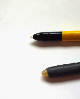 |
| fig.3. Normal and waterproof S Pen (Latex & shrinking hose) |
Comments: Seems to me pretty ideal for mappers. Inductive pen, allweather and easy energy supply handling (no external battery). Total weight: 250gr. Total costs: about 200 CHF /190 Euro (Phone bought second hand)
Software
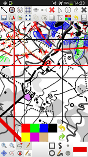 |
| fig.4. Screenshot OOM 0.5.96 with old map as basemap, scribble plus activated GPS tracking and positioning. |
- Open Orienteering Mapper 0.5.96 for Android
Comments: One of the advantages of the OOM is, that you actually can continue working like you did in the analogue days. You just can scribble your features on the map. This is useful for features can not finalize directly (f.ex. wide greens). Of course, the rest you directly draw as map features. Other advantages: it is free and it is under development. You can contribute to its future.
A disadvantage of OOM is that it is not (yet) 100% compatible with recent OCAD formats (bascially some difference in dashing and no virtual gaps in OOM). In the actual case, revising an existing OCAD map, I therefore imported scribble tiles (georeferenced pngs) and digitized objects into OCAD11 for the finishing.
Basemaps
- Snapping Grid
- Old Map in gray and magenta tones
- LiDAR Terrain Model contours 1m
- LiDAR Surface Model (Both slightly outdated (!) therefore an recent additional Aerial)
- Aerial Orthophoto
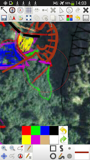 |
| fig.5. Live extraction of natural borders from the orthorectified aerial photo |
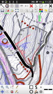 |
| fig.6. Old map overlayed with 1m contours. Also visible the snapping grid (thin hairlines) |
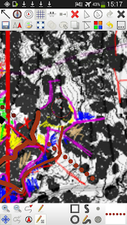 |
| fig.7. Screenshot defining vegetation borders based on the DSM. |
Comments: To fit in changes into the existing map, I use a "snapping grid" consisting in the old map features vector lines. Basically very thin/optionally invisible lines (in protected mode) I can snap to while drawing new features.
In this case the other base maps or "locator maps" where provided. As stated in the quote above the strength of digital mapping is, that you can choose base´maps after the actual situation. In open forest you can identify every single tree with the surface map. In more dense forest the contours are a big help. The internal GPS is indeed the very last measure.
Donnerstag, 21. August 2014
Couch-Mapper: From .las to map without one lung full of fresh air
I here describe the way of the couch-mapper or with other words how far you can get with a swedish .las file (and karttapullautin, OL Laser, Open Street Map, Open Orienteering Mapper and OCAD).
This is a beta version to be enhanced by your feedback.
This is a beta version to be enhanced by your feedback.
Preparation
- If the map you want stretches over more than one tile, use lasmerge to put them all together.Too big files should be avoided though.
- Use las2las or OL-Laser to clip the laser data to the maps perimeter
- Additionally create some suitable smaller clips you can use for the optimization of
- vegetation mapping
- cliff generation
- marsh generation
- Create an OCAD file 1:10000 with the according symbol set. Set the reference system to SWEREF 99 TM.
Vegetation mapping
- Use karttapullautin to generate a vegetation layer. This will build the background of your map. See also karttapullautins vegetation mapping guide
Contours
- Contours you calculate with karttapullautin. Choose the appropriate equidistance.
- Use the out2.dxf from the generated temp-folder.
- Import it into OCAD11 applying a CRT-file. Give contours representing depressions their own symbols.
- Readability: Look over the depressions and manually add 102 slope lines to clarify where necessary.
- Readability: Look over knolls and hilltops. Replace those being to small depending to the situation by 112 small knoll, 113 elongated knoll or 111 minimal knoll according to 112&113 (contour 6x12m).
- Readability: Look over the form lines drawing adding a dash vertex at the right place.
Small knolls
- Small knolls you also get from karttapullautin.
- Use the dotknolls.dxf
- Import into OCAD11 applying a CRT-file or use the function OCAD11>Map>Convert imported layers to symbols after the import.
- Readability: Look over the knolls in regard of the minimal gap to the contours. Move apart if necessary.
Cliffs
- Cliffs you get from OL Laser by creating two sets cliffs, 203 passable rock face (angle 50, height 1.5m, minimal length 5m, snap distance 1m) and 201 impassable cliff (angle 55, height 2.5m, minimal length 8m, snap distance 5m)
- Open the exported .ocd file in OCAD
- Set the reference system to the SWEREF 99TM; save
- Import the .ocd files (do not add colors or symbols thereby)
- Readability: Look over the passable rock faces
- Select all the cliffs shorter than 0.6mm; manually replace them with the point symbol for minimal cliff (0.6mm)
- Draw the longer cliffs with an elegant bezier-curve
- Delete the auto generated cliffs
- Readability: Look over the impassable cliffs
- There should be no cliff shorter than the minimal length of 0.6mm (ISOM 2000)
- Replace the auto generated cliffs with the ones you draw.
Water bodies
- Water bodies digitize yourself based on the a point classification (Laserpunktklass>>Default) image created with OL-Laser.
Marshes / flat terrain
- In this area the marshes mostly are flat. Therefore you can use a base map from OL-Laser to digitize potential marshy areas.
- Basemap: Terrain grid 3x3m; Lutning , 1px; y=-50x2+0x+255;
- 311 is thereby more a symbol for flat terrain. Here you got some freedom to interpret. Develop experience. Double check with aerial photos from eniro.
- The national terrain map 1:50000 can be used as extra information. The approximate position of the bigger marshes can be found there.
Tracks
- Some tracks can be identified with a slope-image (Grid 1x1m; Lutning>Default) or by the intensity image (Grid 1x1m; Intensitet>Default) generated with OL-Laser
- Digitize yourself
- Alternatively the tracks can be imported from Open Street Map alike the buildings; see below
- Readability: Apply dash vertices
Buildings
- If you are lucky, someone already digitized the buildings for Open Street Map and you can just download them.
- Choose the part you want to download from Open Street Map. Save as .osm file.
- Open a new map 1:10000 in Open Orienteering Mapper.
- Import the .osm-file
- Georeference the map, by adding the SWEREF 99 TM proj4 - key
+proj=utm +zone=33 +ellps=GRS80 +towgs84=0,0,0,0,0,0,0 +units=m +no_defs
- Choose "lutning" so that the "grivation" is 0. (Swedish maps are orientated after the reference system)
- Symbolize the content you want, remove the rest, save as .ocd
- Import into OCAD, seems that the georeference gets lost thereby and you have to position the imported "layer" manually. Good if you could identify the position of one of the buildings before importing.
- If you are less lucky, no one digitized the buildings you needed for Open Street Map. As you regularly benefit of Open Street Map the time has come now to contribute. Digitize the buildings on Open Street Map based on aerial images and than proceed as described under the point above.
- Readability: Replace to small buildings with the symbol for the minimal building according to 526 building.
- Other vector data can be integrated from Open Street Map the same way.
Magnetic north lines
- Are to be added in OCAD. OCAD11>Map>create map grid ...
- The calculation of the angle of the north lines = meridian-convergence - magnetic declination
- Readability: clip parts of the north lines affecting the readability of the map
The final result
Open questions
- How to import a geo-referenced file from OOM to OCAD without loosing the geo reference
- An easier way to get to the buildings (the buildings are automatically removed from the .las , maybe one could work with the thereby made holes).
- More information to take from the karttapullautin-dxf-files / a workflow to integrate cliffs from karttapullautin
- How to distinguish open rock from open grassland and maybe a smart setting to define the area 402 half open land with scattered trees in karttapullautin
Abonnieren
Posts (Atom)
o-zeugs over and out (late wc china finding)
Yes. Let the o-zeugs blog rest in peace. I´ll take it down eventually. And yes, I stumbled over the decisions of the Ethics Panel regarding ...

-
Die Karte in besserer Auflösung gibt es in meiner Dropbox (5 MB) Die Rubrik ol früher bezieht sich auf die Zeit vor der Omnipräsenz des I...
-
Yes. Let the o-zeugs blog rest in peace. I´ll take it down eventually. And yes, I stumbled over the decisions of the Ethics Panel regarding ...


